Land Management Operating System
Your Land. Organized.
Plan, manage, track, and preserve everything happening on your property — all in one place.
One organized place for everything happening on your land.
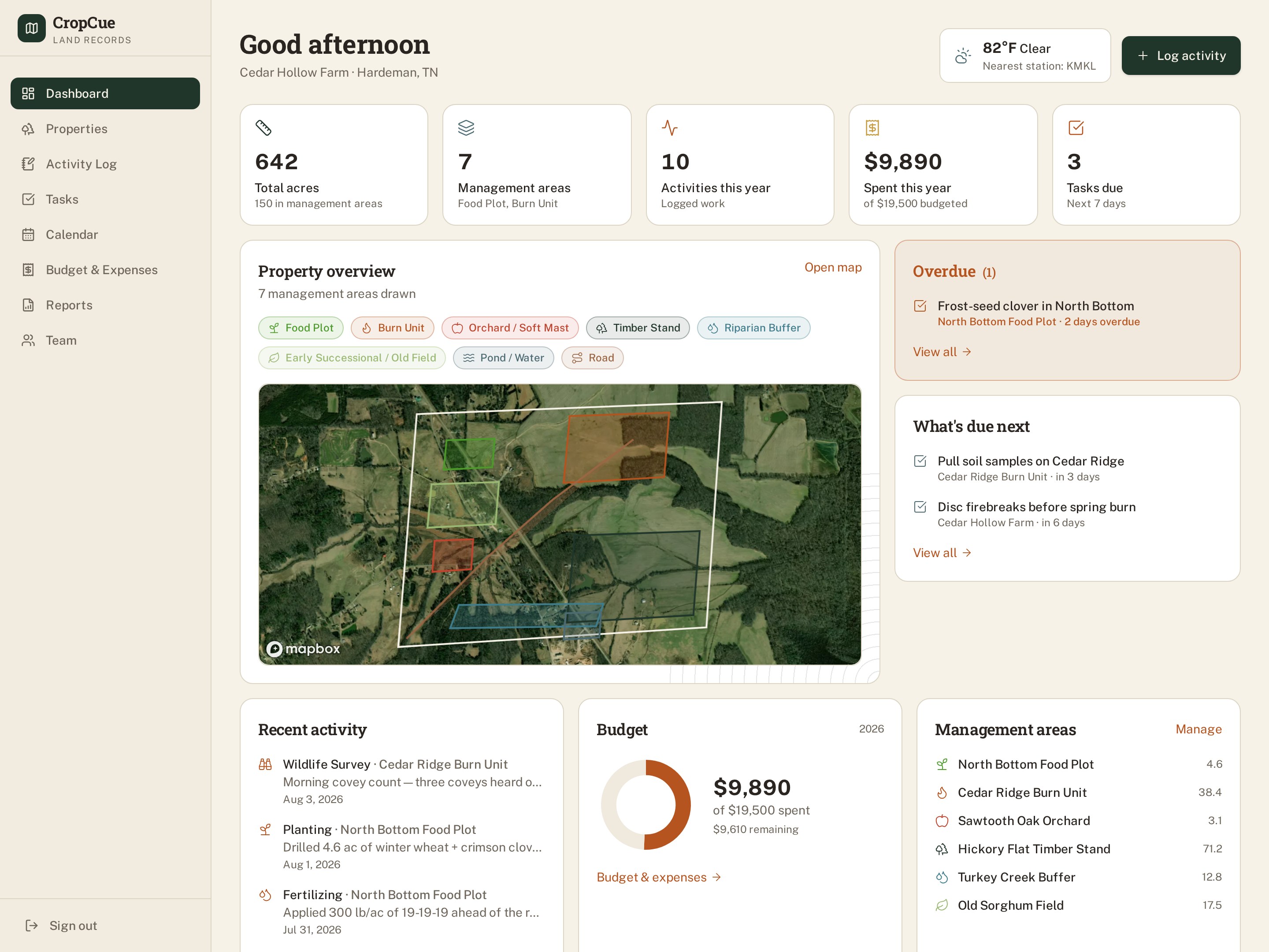
CropCue maps your property, organizes it into management areas, and records every burn, planting, soil test, repair and expense — so the operational history of the land lives in one system instead of six.
- Map it.
- See and organize your property — boundaries, management areas and features on real imagery.
- Manage it.
- Plan work, assign tasks and document what actually happens on the ground.
- Track it.
- Build a permanent history of every activity, improvement and expense.
- Grow it.
- Use better records to make better land-management decisions season after season.
Built for People Who Manage Land
Whether you're managing 40 acres or 40,000, CropCue gives you one organized place to map your land, document the work, track what changes, and preserve the history of your property.
Landowners
Keep projects, improvements, maintenance, maps, property records, documents, and years of land history organized in one place.
Learn moreHunters & Hunting Clubs
Organize food plots, habitat projects, trail cameras, planting, maintenance, property features, and seasonal management activities.
Learn moreLand & Habitat Managers
Plan and document burns, plantings, spraying, soil work, habitat improvements, maintenance, and long-term management progress.
Learn moreFarms, Ranches & Timber
Organize fields, pastures, timber stands, roads, infrastructure, maintenance, projects, and operational history across the property.
Learn moreConsultants & Property Managers
Manage multiple properties, document completed work, maintain consistent records, and provide clients with a clear history of their land.
Learn moreConservation, Research & Agencies
Maintain structured records for habitat projects, research areas, management activities, planning, reporting, and long-term land stewardship.
Learn more
They manage land. CropCue organizes it.
Your land's history is scattered everywhere except where it should be.
Right now it lives in whatever was closest at the time:
- Spreadsheets
- Notebooks
- Mapping apps
- Other apps
- Text messages
- Memory
None of them talk to each other. None of them remember for you.
How it works
- 1
Draw your property
Trace boundaries and management areas directly on satellite imagery — food plots, burn units, timber stands and more.
- 2
Log what you do
Every burn, planting, soil test and expense — with the right calculators built in, not just a blank notes field.
- 3
Watch your history build itself
Every activity becomes part of a permanent, searchable timeline for that property.
- 4
See the full picture
Budgets, weather, team activity and years of decisions — all in one place, not six.
Everything the work actually needs
Interactive property mapping
Draw boundaries and management areas on real satellite imagery, freehand or point-by-point.
Universal activity log
One system for every kind of work — burns, plantings, maintenance, surveys — not a separate app for each.
Budget & expenses
Know exactly what you're spending, by category and by acre, without a spreadsheet.
Built-in calculators
Pure live seed rates, lime recommendations, soil test tracking — real land-management math, not guesswork.
Weather, on location
Live conditions and forecasts pulled from the nearest weather station to your actual property.
Team collaboration
Bring in managers, consultants and club members — everyone logs to the same record.
Your land already has a story. Start recording it.
CropCue is in a closed beta — invites go out in small groups.